


Maricopa Voting District, Pinal County, Arizona
About
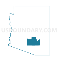
Outline

Summary
| Unique Area Identifier | 525571 |
| Name | Maricopa Voting District |
| County | Pinal County |
| State | Arizona |
| Area (square miles) | 48.77 |
| Land Area (square miles) | 48.70 |
| Water Area (square miles) | 0.07 |
| % of Land Area | 99.86 |
| % of Water Area | 0.14 |
| Latitude of the Internal Point | 32.93063630 |
| Longtitude of the Internal Point | -111.95910360 |
Maps


Graphs
Select a template below for downloading or customizing gragh for Maricopa Voting District, Pinal County, Arizona


Neighbors
Neighoring Voting District (by Name) Neighboring Voting District on the Map
- Ak-Chin Community Voting District, Pinal County, AZ
- Casa Blanca Voting District, Pinal County, AZ
- Casa Grande NW Voting District, Pinal County, AZ
- Casa Grande SW Voting District, Pinal County, AZ
- Hidden Valley Voting District, Pinal County, AZ
- Maricopa Fiesta Voting District, Pinal County, AZ
- Maricopa Meadows Voting District, Pinal County, AZ
- Province Voting District, Pinal County, AZ
- Santa Rosa Voting District, Pinal County, AZ
- Stanfield Voting District, Pinal County, AZ
- Tbird Farms Voting District, Pinal County, AZ
Top 10 Neighboring County Subdivision (by Population) Neighboring County Subdivision on the Map
- Casa Grande CCD, Pinal County, AZ (57,701)
- Maricopa-Stanfield CCD, Pinal County, AZ (52,536)
- Gila River CCD, Pinal County, AZ (8,771)
Top 10 Neighboring Place (by Population) Neighboring Place on the Map
Top 10 Neighboring Elementary School District (by Population) Neighboring Elementary School District on the Map
- Casa Grande Elementary District, AZ (60,768)
- Sacaton Elementary District, AZ (6,582)
- Stanfield Elementary District, AZ (5,193)
Top 10 Neighboring Secondary School District (by Population) Neighboring Secondary School District on the Map
Top 10 Neighboring Unified School District (by Population) Neighboring Unified School District on the Map
Top 10 Neighboring State Legislative District Lower Chamber (by Population) Neighboring State Legislative District Lower Chamber on the Map
Top 10 Neighboring State Legislative District Upper Chamber (by Population) Neighboring State Legislative District Upper Chamber on the Map
Top 10 Neighboring 111th Congressional District (by Population) Neighboring 111th Congressional District on the Map
Top 10 Neighboring Census Tract (by Population) Neighboring Census Tract on the Map
- Census Tract 9414, Pinal County, AZ (8,497)
- Census Tract 17.04, Pinal County, AZ (6,420)
- Census Tract 17.08, Pinal County, AZ (5,979)
- Census Tract 16, Pinal County, AZ (5,433)
- Census Tract 17.07, Pinal County, AZ (5,070)
- Census Tract 17.06, Pinal County, AZ (4,872)
- Census Tract 17.10, Pinal County, AZ (4,324)
- Census Tract 17.09, Pinal County, AZ (2,738)
- Census Tract 9413, Pinal County, AZ (2,730)
- Census Tract 17.02, Pinal County, AZ (2,727)